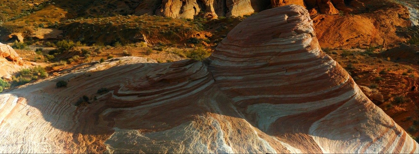
 Sandstone Wave
A sandstone wave formation in Red Rock Canyon, Nevada
Uploaded 2019-01-31 10:25:29 by Jason Buchheim username:odyssey copyright 2019-01-31 10:25:29
11,892px by 4,394px, 0.05 Gigapixels
| Unmounted | Acrylic Museum Mount |
| Purchase Prints | Matte | Glossy | Lustre | Metalic | Deep Glossy | Deep Glossy |
| 12" x 32" | | | | | | |
VIEW OPTIONS please select the approximate angle of view of the image
Flat 1° 10° 45° 90° 170°
Sphere 45° 90° 180° 270° 360°
Odyssey Expeditions Panoram.io VR billboard style
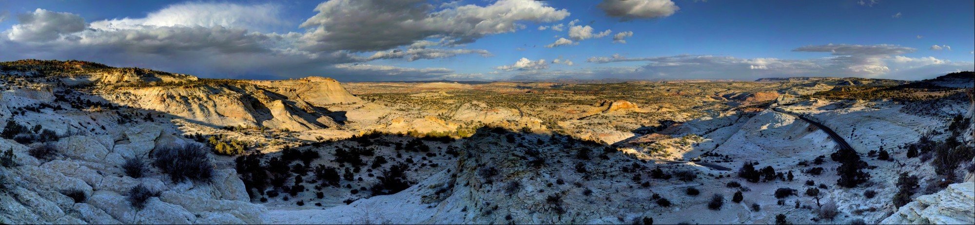 Grand Staircase Escalante
A Southeastern viewpoint looking at the Grand Staircase Escalante in Utah
Uploaded 2018-11-23 00:19:25 by Jason Buchheim username:odyssey copyright 2018-11-23 00:19:25
36,323px by 8,384px, 0.30 Gigapixels
| Unmounted | Acrylic Museum Mount |
| Purchase Prints | Matte | Glossy | Lustre | Metalic | Deep Glossy | Deep Glossy |
| 12" x 52" | | | | | | |
| 18" x 78" | | | | | | |
| 24" x 104" | | | | | | |
VIEW OPTIONS please select the approximate angle of view of the image
Flat 1° 10° 45° 90° 170°
Sphere 45° 90° 180° 270° 360°
Odyssey Expeditions Panoram.io VR billboard style
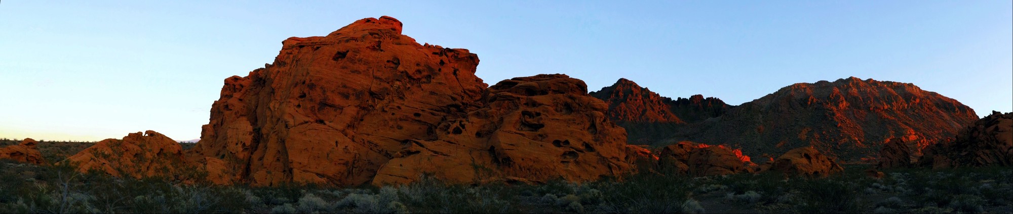 Sunset on Rocks, Lake Mead National Recreation Area
Beautiful Light on the rocks at sunset, Lake Mead National Recreation Area
Uploaded 2016-11-23 15:04:19 by Jason Buchheim username:odyssey copyright 2016-11-23 15:04:19
20,418px by 4,331px, 0.09 Gigapixels
| Unmounted | Acrylic Museum Mount |
| Purchase Prints | Matte | Glossy | Lustre | Metalic | Deep Glossy | Deep Glossy |
| 12" x 57" | | | | | | |
VIEW OPTIONS please select the approximate angle of view of the image
Flat 1° 10° 45° 90° 170°
Sphere 45° 90° 180° 270° 360°
Odyssey Expeditions Panoram.io VR billboard style
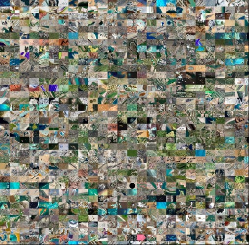 1000 Beautiful Places on Earth Mosaic
Mosaic of 1000 Beautiful and Interesting Places on Planet Earth,
Uploaded 2014-11-12 21:39:50 by Jason Buchheim username:odyssey copyright 2014-11-12 21:39:50
45,742px by 45,033px, 2.06 Gigapixels
| Unmounted | Acrylic Museum Mount |
| Purchase Prints | Matte | Glossy | Lustre | Metalic | Deep Glossy | Deep Glossy |
| 12" x 12" | | | | | | |
| 18" x 18" | | | | | | |
| 24" x 24" | | | | | | |
| 30" x 30" | | | | | | |
| 36" x 37" | | | | | | |
VIEW OPTIONS please select the approximate angle of view of the image
Flat 1° 10° 45° 90° 170°
Sphere 45° 90° 180° 270° 360°
Odyssey Expeditions Panoram.io VR billboard style
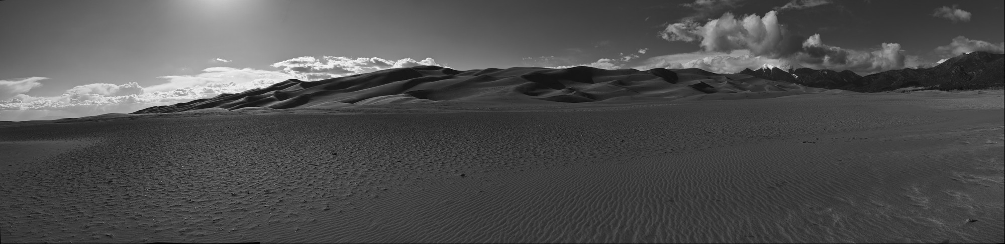 Great Sand Dunes National Park, Colorado
Shot handheld with Sigma DP2Merrill Camera assisted by the iOS app 'HandiPan' Shot in RAW mode and converted to Black and White within the Sigma Photo Pro Raw conversion application.
Uploaded 2013-05-16 00:19:02 by Jason Buchheim username:odyssey copyright 2013-05-16 00:19:02
20,525px by 5,000px, 0.10 Gigapixels
| Unmounted | Acrylic Museum Mount |
| Purchase Prints | Matte | Glossy | Lustre | Metalic | Deep Glossy | Deep Glossy |
| 12" x 49" | | | | | | |
VIEW OPTIONS please select the approximate angle of view of the image
Flat 1° 10° 45° 90° 170°
Sphere 45° 90° 180° 270° 360°
Odyssey Expeditions Panoram.io VR billboard style
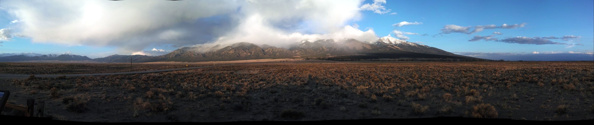
 Blanca Peak, Colorado
Blanca Peak is the highest peak of the Sierra Blanca Massif at the southern tip of the Sangre de Cristo Range in the U.S. State of Colorado. It is the fourth highest peak of the Rocky Mountains, and the eighth highest peak in the contiguous United States.
.
.
Geography
.
It is located at the southern end of the Sangre de Cristo Range, a subrange of the larger Sangre de Cristo Mountains, and is the highest peak in both ranges. It marks the common boundary of Huerfano, Costilla and Alamosa counties, approximately 20 miles (32 km) east-northeast of the town of Alamosa. Approximately 15 miles (24 km) to the north-northwest is Great Sand Dunes National Park and Preserve.
.
Blanca Peak is notable not only for its absolute height, but also for its great local relief and dominant position at the end of the range, rising high above the San Luis Valley to the west. For example, it rises nearly 7,000 feet (2,100 m) over the edge of the San Luis Valley in only 6 miles (9.7 km). Blanca is also the third most topographically prominent peak in Colorado; it is separated from the higher peaks in the Sawatch Range by relatively low Medano Pass at 9,982 feet (3,043 m).
.
Blanca Peak heads up three major creeks. Holbrook Creek is on the west, flowing from a basin including Crater Lake, Blue Lakes, and Como Lake. An extremely challenging four wheel drive road accesses Como Lake 11,750 feet (3,580 m), and provides the most common access to Blanca Peak. Most vehicles stop at an elevation of between 8,000 feet (2,400 m) and 10,000 feet (3,000 m) on this road. The Como Lake Road is a designated Alamosa County Road and runs to the edge of the Sangre de Cristo Wilderness just short of Blue Lakes. The Como Lake Road is rated as the most challenging 4WD road in Colorado. The Huerfano River flows from the north side of Blanca Peak. A road, starting out as a two wheel drive road, then becoming a four wheel drive road (less challenging than the Como Lake Road), provides access to the technical climbing on the North Face of Blanca Peak. Blanca Creek drains Blanca Basin under the south slopes of the peak, and Little Ute Creek descends from the Winchell Lakes on the southeast side. However these are not used to access the peak due to private property.
.
Three other fourteeners are nearby: Mount Lindsey to the east, Ellingwood Point to the north and Little Bear Peak to the southwest. Ellingwood Point is connected to Blanca by a short, high ridge, and is often climbed in conjunction with Blanca. Little Bear also has a high connecting ridge to Blanca, but it is a technical traverse, only recommended for highly experienced parties.
.
Geology
.
The granite that makes up the Blanca massif is pre-Cambrian in age, dated at approximately 1.8 billion years old. The major part of the Wet Mountains to the east and the Front Range to the northeast are also pre-Cambrian, also about 1.8 billion years old. In contrast, the Sangre de Cristo Range to the north and the Culebra Range to the south are Permian rock between 250 and 300 million years old.
.
History
.
Blanca Peak is known to the Navajo people as the Sacred Mountain of the East: Sisnaajin� (or Tsisnaasjin�), the Dawn or White Shell Mountain. The mountain is considered to be the eastern boundary of the Dinetah, the traditional Navajo homeland. It is associated with the color white, and is said to be covered in daylight and dawn and fastened to the ground with lightning. It is gendered male.
.
Summitpost notes that "the first recorded ascent of Blanca by the Wheeler Survey was recorded on August 14, 1874, but to their surprise they found evidence of a stone structure possibly built by Ute Indians or wandering Spaniards."
.
Shot handheld with a Sigma DP2 Merrill camera.
Uploaded 2013-05-14 10:48:47 by Jason Buchheim username:odyssey copyright 2013-05-10 00:00:00
12,541px by 5,000px, 0.06 Gigapixels
| Unmounted | Acrylic Museum Mount |
| Purchase Prints | Matte | Glossy | Lustre | Metalic | Deep Glossy | Deep Glossy |
| 12" x 30" | | | | | | |
VIEW OPTIONS please select the approximate angle of view of the image
Flat 1° 10° 45° 90° 170°
Sphere 45° 90° 180° 270° 360°
Odyssey Expeditions Panoram.io VR billboard style
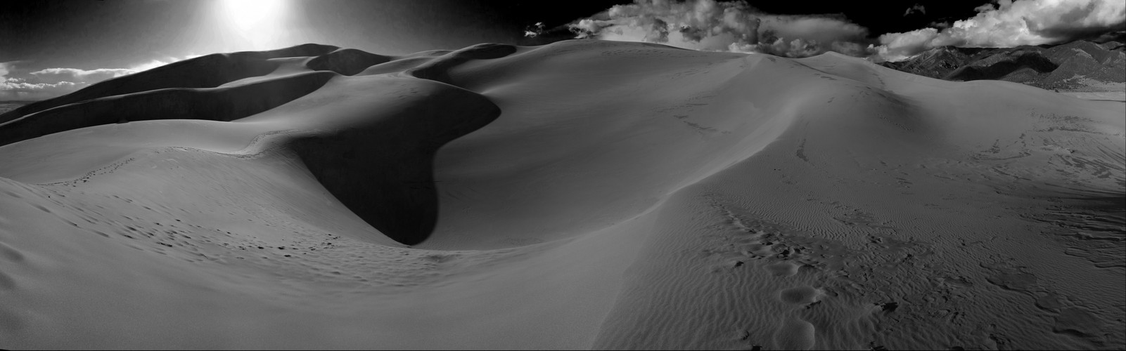 Great Sand Dunes National Park
The Great Sand Dunes National Park, Colorado. Photographed handheld with a Sigma DP2 Merrill Camera using the iOS app 'HandiPan'
Uploaded 2013-05-14 01:05:13 by Jason Buchheim username:odyssey copyright 2013-05-14 01:05:13
22,635px by 7,069px, 0.16 Gigapixels
| Unmounted | Acrylic Museum Mount |
| Purchase Prints | Matte | Glossy | Lustre | Metalic | Deep Glossy | Deep Glossy |
| 12" x 38" | | | | | | |
| 18" x 58" | | | | | | |
VIEW OPTIONS please select the approximate angle of view of the image
Flat 1° 10° 45° 90° 170°
Sphere 45° 90° 180° 270° 360°
Odyssey Expeditions Panoram.io VR billboard style
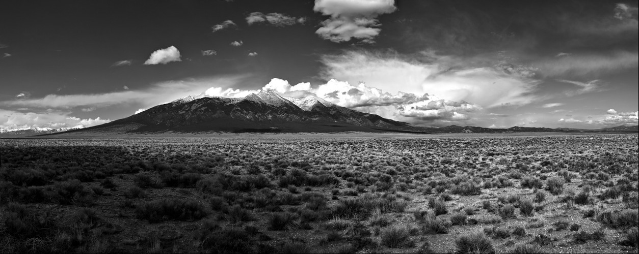
 Le Blanca Mountain, Colorado
Taken with a Sigma DP2M camera, handheld with the Handipan iOS aplication. La Blanca is the fourth highest mountain in Colorado and rises 6000 feet from the valley floor, making for a very strikingly tall, beautiful mountain. The Great Sand Dunes are to the left.
Uploaded 2013-05-13 22:44:19 by Jason Buchheim username:odyssey copyright 2013-05-13 22:44:19
22,308px by 4,722px, 0.11 Gigapixels
| Unmounted | Acrylic Museum Mount |
| Purchase Prints | Matte | Glossy | Lustre | Metalic | Deep Glossy | Deep Glossy |
| 12" x 57" | | | | | | |
VIEW OPTIONS please select the approximate angle of view of the image
Flat 1° 10° 45° 90° 170°
Sphere 45° 90° 180° 270° 360°
Odyssey Expeditions Panoram.io VR billboard style
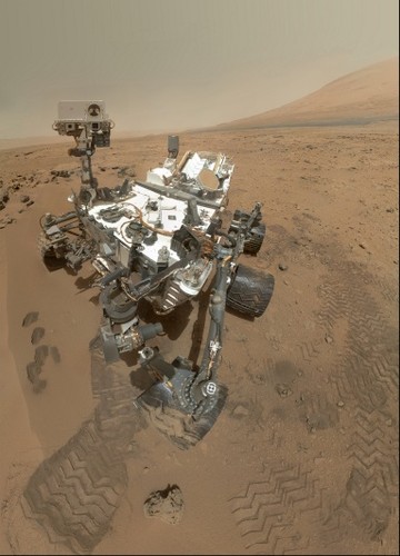 High-Resolution Self-Portrait by Curiosity Rover Arm Camera - PIA16239
On Sol 84 (Oct. 31, 2012), NASA's Curiosity rover used the Mars Hand Lens Imager (MAHLI) to capture this set of 55 high-resolution images, which were stitched together to create this full-color self-portrait.
The mosaic shows the rover at "Rocknest," the spot in Gale Crater where the mission's first scoop sampling took place. Four scoop scars can be seen in the regolith in front of the rover.
The base of Gale Crater's 3-mile-high (5-kilometer) sedimentary mountain, Mount Sharp, rises on the right side of the frame. Mountains in the background to the left are the northern wall of Gale Crater. The Martian landscape appears inverted within the round, reflective ChemCam instrument at the top of the rover's mast.
Self-portraits like this one document the state of the rover and allow mission engineers to track changes over time, such as dust accumulation and wheel wear. Due to its location on the end of the robotic arm, only MAHLI (among the rover's 17 cameras) is able to image some parts of the craft, including the port-side wheels.
This high-resolution mosaic is a more detailed version of the low-resolution version created with thumbnail images, at PIA16238.
JPL manages the Mars Science Laboratory/Curiosity for NASA's Science Mission Directorate in Washington. The rover was designed, developed and assembled at JPL, a division of the California Institute of Technology in Pasadena.
For more about NASA's Curiosity mission, visit: http://www.jpl.nasa.gov/msl, http://www.nasa.gov/mars, and http://mars.jpl.nasa.gov/msl.
Image Credit:
NASA/JPL-Caltech/Malin Space Science Systems
Image Addition Date:
2012-11-01
Uploaded 2012-11-05 10:00:48 by Jason Buchheim username:odyssey copyright 2012-11-05 10:00:48
6,114px by 8,500px, 0.05 Gigapixels
| Unmounted | Acrylic Museum Mount |
| Purchase Prints | Matte | Glossy | Lustre | Metalic | Deep Glossy | Deep Glossy |
| 12" x 9" | | | | | | |
| 18" x 13" | | | | | | |
| 24" x 17" | | | | | | |
VIEW OPTIONS please select the approximate angle of view of the image
Flat 1° 10° 45° 90° 170°
Sphere 45° 90° 180° 270° 360°
Odyssey Expeditions Panoram.io VR billboard style
All images uploaded to and reside only at Gigapan®.com. Image copyrights by respective photographers.
This site does not copy or store any images and only provides the viewer KRPANO panorama viewing software, necessary configuration XML and proxy using the public Gigapan® API.